"Adobe Photo Shop:" What a wonderful graphics graphics program! The ad on the left side of the graphic from the Hotel Hildebrecht Thanksgiving season of 1934, blends in perfectly with this West State Street view of the hotel as it looked back in the 1930's. Converting the black and white Hildebrecht ad to sepia and adding the free clip art from the "HOLIDAYS" folder in the Hamilton Library Local History Collection makes for a lasting tribute to the Thanksgiving season of the 1930's. It has been resurrected and posted as a 2012 Thanksgiving Day greeting from the Hamilton Township Public Library!
Search This Blog
Thursday, November 15, 2012
Tuesday, November 13, 2012
1945: HAMILTON AVENUE AT NORWAY HEADING TO NEWKIRK AVENUE
I published a similar graphic to this one some time back. This is very familiar territory for me....indeed, it is one block away from Kuser School, my grammar school alma mater. Up the road to the right is Atlantic Avenue, the street on which I have been living for 50 plus years.
1940: "HOJO" AND THEIR 28 FLAVORS
I never did try all 28 flavors, but they sure did have delightful ice cream. This photo will warm the heart of any of my contemporaries who dined at Howard Johnson's back in the day. Note the road side designation Route 25 and 206.
Saturday, November 10, 2012
1934: FROM TROLLEYS TO BUSES
1934: THE TRENTON EAGLES FOOTBALL TEAM
See how much you can learn when you page through this web site? Whoever knew that there was a football team known as the Trenton Eagles? Above is a 1934 news photo of the team, and lo and behold, there's another Lucarella sportsman in the photo. I have copied, enlarged, and pasted "Chick" Lucarella and I assume that would be our own Ralph Lucarella's brother Chuck. Now you know why the Hamilton Township Public Library's Local History Collection is sub-titled,
"Local History With A Personal Touch!"
1950's: HOW RURAL WERE WE? LET ME COUNT THE WAYS!
It is nearly impossible for the younger generation to understand how very rural Hamilton Township was just 50 short years ago. Anywhere you drove, north, south, east or west, as you left any of our local neighborhoods and ventured out into "the country," you would see fields of corn, alfalfa, and other expansive farms. Can you even try to consider today's intersection with Youngs Road and the photo above? Mind boggling!
1940'S: RENNIE STREET, BROAD STREET PARK
Attention Jim Colello: Here's a nice vintage BSP photo for you to include in your "BROAD STREET PARK YESTERYEARS" website. ( www.bsp086.blogspot.com.) It will take someone far more knowledgeable than I on the Broad Street Park area to pinpoint this photo. I thought the building right behind the Kirby and Kirby sign was Hamilton High School, but a Google Earth search proved to be more confusing.
Questions to our Broad Street Park Historian:
Is the photo taken with the photographer standing on Rennie? If so, what is the cross street at the intersection? What is the building on the right? SOS, Jim.
Friday, November 09, 2012
1934: ROCKHILL HART-VETERAN TOWNSHIP CLERK
Many
people who are not familiar with Hamilton Township history will not
recognize the name of Rockhill Hart. As can be seen in the above
article, he was one of Hamilton's pioneer figures from the mid 18th
century up to 80th birthday in 1934. It is interesting to note that his
office was also in the same building as one of the original Hamilton
Township jails. (There was also a township jail located on Schiller
Avenue in Broad Street Park, in a building today occupied by the Marine
Corps League.)
Jim C said...
Jim C said...
A jail was located on Schiller Avenue, Broad Street Park, but was not the
building currently occupied by the Marine Corps League. The building
was a separate building on the lot that sat in the southeast corner of
the property.
1947: TOM REMEMBERS DICK AND JANE
I painstakingly assembled this graphic to give an idea of the first "reader" those of my generation were exposed to. As I opined in the graphic, memories of Dick and Jane was the introduction given to little boys and girls of my generation in many school districts across America. Learning to read was a joy as we read the adventures of Dick, Jane, Mother, Father, Spot, and Puff. Even as I realize that relatively few of my generation are on the computer, I would be interested in knowing if any of our more adventurous computer users from my generation were also exposed to this childhood treasure.
1934: CHILDREN'S BOOK WEEK AT THE LIBRARY
This photo was taken when the Hamilton Township Public Library was located in the basement of the township municipal building at 2090 Greenwood Avenue. I have many pleasant memories of visiting that small and austere library back in the 1940's and early 1950's. The Dewey decimal system survives, but long gone are the cabinets that held those little library cards that listed titles, location, etc.
Thursday, November 08, 2012
1940? A WEDDING AT THE HAMILTON POLICE STATION
First of all, I am assuming that the beautiful Packard sedan in the photo is possibly a 1940, but as usual will depend on my good buddy and automotive historian Ray Paskiewicz to keep me honest and correct the date should I have chosen the incorrect year. Secondly, and again speculation, that that old Packard is parked in front of the Harrison Avenue Police Station where there is a wedding being performed, after which the newlyweds will head out for their honeymoon.
1949: TRACY'S "FIVE AND DIME"
Tracy's! Now you're in my "stamping grounds." I remember my many visits to Tracy's on Hamilton Avenue across from Steinel's Pharmacy and catty corner (that's diagonally across) Hamilton and Olden were Mr. Schnur had Schnur's Five and Dime. Mr. Schnur was a wonderful man. Back in my youth, Mom Glover took me there to buy "cancellation" shoes which were shoes with minor imperfections sold an an incredibly low price. Mr. Schnur always took a close look at our shoe purchase, and if he saw a glaring imperfection, he would suggest another pair. As I look back after all these years, I realize that Mr. Schnur was much like "Ike" Godsey of Walton's Mountain; a down to earth storekeeper who knew and respected his customers.
1941: HOWARD JOHNSON ROUTE 25 BORDENTOWN
Back when I was a new teenage driver, one of the things I and my buddies did as we cruised around the area when gas was 19.9 cents per gallon, was to drive up what was then known as the "highway of death" due to all the many accidents and the truck traffic that traversed north and south before the N.J. Turnpike was built. They were such simple pleasures: We would let those 18 wheelers pass us and as they did we would blink our headlights telling him it was OK for him to go back into the right lane ahead of us. He in turn would return the courtesy with a blink of his tail lights as he changed lanes and slipped in front of us. We often rode Route 25 (today's U.S. Route 130, occasionally stopping at Bordentown's Hamburger Haven, a trip to Millside Farms for a banana boat, or sampling one of Howard Johnson's 28 flavors. Ahh, memories are indeed made of this!
WHOA; LOOK AT ROUTE 33 WAY BACK WHEN!
I must have spent the better part of an hour trying to place this early photo of one of Hamilton's busiest intersections. The little house on the right doesn't seen to appear as I traversed the intersection via Google Earth. The cyclone link fence on the right completely mystifies me, as does the road sign which is out of focus. Is it pointing to Mercerville and 5 points, or is it pointing to White Horse and points south. Hopefully there will be another Ralph Lucarella guy (or Ralph himeself) who can help with this, as the sign says, "DANGEROUS INTERSECTION;" No traffic lights at this busy intersection back then. Speculation invited.
As an interesting aside, I and my teen age buddies traveled this road countless times back in the late 1940's and early 50's as we drove to Betty and Bill's drive in restaurant across from the Mozer farm on Route 33. My mind is a blank. We took this intersection for granted as always being familiar.
1912: HAMILTON FIRE COMPANY IN RURAL BROMLEY
Frank Vliet and Alvin Sykes were prominent Hamilton Township citizens back in the early years of Hamilton Township. Vliet, who lived on Johnston Avenue, was an early proponent of assuring that Bromley got a fair share of township services. The above articles from the local press point to the austere beginnings of Hamilton's legendary "Hamilton Fire Company," whose building I have posted above showing the front facade. Given the incredible growth of Hamilton Township since the mid 1950's, reading the above verbal letters to the editor point to the rural condition of Hamilton as the suburbs began to spread eastward from Trenton.
Wednesday, November 07, 2012
1948 Ca. 1948 South Broad St. at White Horse Avenue
What an incredible and rare photo! I was just at the present Taco Bell yesterday afternoon to pickup our dinner. The vacant lot on the right is the site of the current occupant, Taco Bell. That house in the background is still there. In all my years of venturing into that neighborhood, I can't recall this view. "Scotty's" teen hangout is to the right and down South Broad Street a bit. It was here that my dear wife of 58 years spent many happy hours before I met her. Scotty's was a very popular teen hangout in the 1950's.
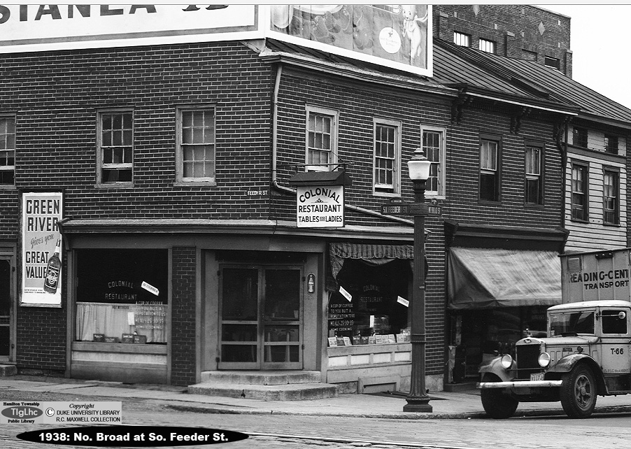
1938: THE COLONIAL RESTAURANT, NORTH BROAD AND FEEDER STREET
This is still another "segmented" closeup of the restaurant that once reposed on the corner of Feeder and North Broad Street in Trenton. That gorgeous Mack truck idling on the corner adds to the charm of this vintage look at the Trenton of some 74 years ago.
A note about "segmented:" The original view was posted earlier and encompassed a larger view of the area. However, the detail on these photos is so detailed, that specific subjects can be enhanced and given a whole new and closer look at a specific neighborhood.
1936: AN EXQUISITE R.C. MAXWELL TRENTON VIEW
1939: NO. WARREN STREET AT THE RR CROSSING
The beautiful spire on St. Mary's Cathedral looms majestically in this scene of North Warren Street heading toward West State Street. Passing by this exact location will give a completely foreign aspect, given the many changes that have transpired in that neighborhood over these past 73 years.
Monday, November 05, 2012
1939: LONG'S DRUG STORE
As I seem to recall, Longs had a number of locations over many years. I seem to remember Greenwood and Olden Avenue, and also Hamilton and Olden Avenue. This photo shows a much different East State Street when compared to the same location today..
1941: BEFORE THE WHITE HORSE CIRCLE
This familiar intersection is very familiar to me. The intersection in the photo is completely unfamiliar to me. I can honestly say I do not recall Route 206 merging with South Broad Street at the White Horse Avenue (White Horse - Mercerville Road). How very rural we were back when I was 8 years old! I must admit that I don't even remember this intersection 10 years later when I was a senior at HHS and often traversed South Broad Street.
1938: North Broad at South Feeder Street
Here's another segmented view of the Battle Monument area of Trenton at the Feeder Street intersection. It would be interesting if any visitors recall that restaurant; that area was never a familiar section of Trenton to me. As usual, the clarity on this Maxwell photo is superb.
Friday, November 02, 2012
2012: "SANDY" WROUGHT HAVOC ALL OVER MERCER COUNTY
This website has also been a victim of the tragic hurricane that hit us a few days ago. The Hamilton Library was closed on Monday and Tuesday, the 29th and 30th of October. As a result, many of the posts I was working on were left undone. However, we are back on line and will once again be diligently posting interesting graphics. Thank you for your patience and indulgence.
- RALPH LUCARELLA said...
- HI TOM....THIS IS ONE TIME THAT FLORIDA WAS NOT INVOLVED BY A
HURRICANE. WE LEFT FLORIDA AFTER MANY YEARS BECAUSE OF THE HURRICANES
AND SINCE THEN THERE HAVE BEEN FEW. I UNDERSTAND MERCERVILLE AND MANY
OTHER SECTIONS OF THE CITY ARE WITHOUT POWER AND I NEVER HEARD OF SOUCH
DAMAGE IN THE NEW YORK AREA. MY PRAYERS GO OUT TO THEM. REGARDS
Friday, November 02, 2012
-
Tom Glover said... - RALPH, IN ALL MY YEARS I HAVE SEEN MANY EAST COAST HURRICANES. MY
2 ARMY BUDDIES DROVE TO TRENTON ON A WEEKEND PASS BACK IN THE 1950'S
AND WENT RIGHT DOWN THE BOSTON POST ROAD AND INTO A HURRICANE. IT WAS
REALLY SCARY. WE LOST POWER IN THE HAMILTON AREA OF TRENTON FOR AT LEAST
10 DAYS. HOWEVER, THIS MONSTER STORM NAMED SANDY WAS UNIMAGINABLE IN
THE DAMAGE. LONG BEACH ISLAND WAS DECIMATED, SEASIDE HEIGHTS LOST ALL
THEIR RIDES, ATLANTIC CITY LOST A HUGE NUMBER OF BOARDS FROM THE
BOARDWALK, AND IN NEW YORK, THOUSANDS ARE STILL WITHOUT POWER WITH A
COLD FRONT COMING INTO THE EAST COAST. MY FAMILY CAME THROUGH WITH NARY A
PROBLEM. EVEN MY HAM RADIO ANTENNA UP 50 FEET BETWEEN TWO ASH TREES
SURVIVED THE 70 TO 75 MPH WINDS. THIS ONE WAS WORSE THAN THE 1938
HURRICANE THAT DESTROYED THE NORTHEASTERN CITIES.
TOM GLOVER
Friday, November 02, 2012
-
RALPH LUCARELLA said... - I RECALL TON, WHEN WE WERE LIVING ON EDINBURG ROAD IN THE 50'S,
SOME VERY BAD STORMS BUT NEVER LIKE THIS ONE. I CAN'T IMAGINE THE NEW
YORK AND JERSEY SHORE AREA LOSING THEIR POWER FOR SO LONG AND KEEP
PEOPLE FROM USING THEIR CAR THRU GAS SHORTAGE. IT'S PRETTY SCARY TO
WATCH THE DAMAGE ON T.V. I THINK THERE'S A CLIMATE CHANGE ALL OVER THE
WORLD. LET'S HOPE FOR THE BEST.
Saturday, November 03, 2012
-
Ron Bound said... - Tom and Ralph, glad you are safe. Such sadness, with all the
destruction. And the long recovery period ahead. Ralph, one of our
friends left Pensacola to get away from the Hurricanes, and moved to
Cape May a couple years ago. Haven't heard from her.
In 1954, my brother and I walked back to our old neighborhood, in the Burg, with the winds still howling and the rain still coming down. Stood on buddies stoop, not more than 3 by 3 feet, wood. Heard a noise, and one of us jumped into the buddies house, and the other jumped onto a covered porch, and CRASH, there was half the red brick chimney with the antenna still attached, right where we had been standing...it just wasn't our time. Later in Sept 1960 I tracked Hurricane Donna...which was headed right for our AF Base in Tampa. When my latest report showed the storm had turned NE towards Orlando, instead of coming our way, Tampa, my Commander was relieved. So was I. You are all in our prayers. Ron and Marie
Sunday, November 04, 2012
-
Sally Logan Gilman said... - Hi Tom:I'm glad you and your family weathered the storm. I can
remember the 1954 storm and the trees that were brought down. The
destruction on the Jersey Shore and Staten Island is horrendous and is
something that I have never seen before. We were grousing because we
were without power for two days in NH. I will never complain again.
Regards
Sunday, November 04, 2012
Wednesday, October 31, 2012
1934: W. HANOVER AND CALHOUN STREET APPROACHING THE BRIDGE
Here is a familiar view to many of us who traveled the Calhoun Street of old. I have scanned this in very high dots per inch to let you see the incredible details in the photo. I tried to enhance that black sign in the photo, but it was apparently painted over with a white coating and still shows the original Coca Cola ad.
1922: 300 BLOCK E. STATE STREET; CITY HALL AREA
Even though I wish that trolley had passed out of the viewfinder on this Maxwell photo, it provides a nice in-motion photo of what a trolley looked like back in the roaring twenties. The young lad in knickers scampering along E. State Street adds a bit of 1920's nostalgia.
2012: OCTOBER 30: HURRICANE SANDY AT KUSER FARM PARK
TODAY (OCTOBER 31) IS MY FIRST DAY BACK AT THE LOCAL HISTORY WORKSHOP IN THE HAMILTON TOWNSHIP PUBLIC LIBRARY. IT WAS A VERY STRESSFUL TIME FOR MANY LOCALS, MYSELF INCLUDED AS WE ALL WAITED TO SEE WHAT HAVOC HURRICANE SANDY WOULD BRING TO THE MERCER COUNTY AREA. THE SERIES OF PHOTOS BELOW SHOW THE RESULTS OF SANDY'S VISIT TO THE KUSER FARM. THESE ARE ONLY TWO OF THE MANY TREES THAT WERE LOST OVER IN THE WOODED AREA BORDERING NEWKIRK AVENUE. THE LAST TIME I WAS INVOLVED WITH A HURRICANE AT KUSER FARM WAS BACK IN NOVEMBER, 1950 WHEN A DEVASTATING HURRICANE KNOCKED DOWN COUNTLESS TREES AT THE FARM. BACK THEN, WE USED A TWO MAN CROSSCUT SAW, A SLEDGE HAMMER, AND A STEEL WEDGE TO CLEAN UP MANY, BUT NOT ALL OF THE DOWNED TREES.
Friday, October 26, 2012
1940: BERNIE'S HEALTH CENTER
Of course, this graphic would make you wonder if there is a relationship with today's locally noted bicycle shop on Route 33 in Mercerville. Perhaps someone who knows Bernie's family can tell us about this interesting establishment.
Thursday, October 25, 2012
1949: PENNINGTON ROAD AND NO. OLDEN AVENUE
It took a little longer than I expected to come up with this location due to the fact that it has changes so very much. It gives a good idea of just how rural we were back in the late 40's and early 1950's. I blew up the original and lo and behold, I was right! The enlarged cut and paste of the road sign lower left removes all doubt that my guess was accurate. Am I correct in remembering that the big green and white mansion (not seen in the photo on the other side of the house on North Olden Avenue was the Glenside, or am I fabricating history?
1950: HEY, THAT'S GRAVATT'S FROZEN CUSTARD!
It took me a little while to locate this location which R.C. Maxwell labeled as "UNTITLED." Those High tension wires, the dual lane highway, and the partially seen but very familiar vanilla frozen custard roof on the earliest known area frozen custard establishment verified that we are on South Broad Street just across the highway from today's Independence Mall shopping center.Can anyone identify that white building in the foreground? Can anyone associate that "GOLF" sign with Vic Rice's? Comments, please.
THANKS FOR CORRECTING ME AND MY SENILE MOMENT, MIKE. OF CURSE IT WAS GRAVATTS! SORRY FOR THE GOOF.
1950: REMEMBERING THE LANGHORNE SPEEDWAY
One would have a very hard time trying to find the actual location of the fabled Langhorne Speedway as it was back some 60 plus years ago. The area is completely built up, and if perchance a visitor to this website can place the race track in relation to the terrain today, we would be eternally grateful. I seem to remember that it wasn't too far from the new Levittown that sprung up during that era.
1951: PROSPECT STREET AT THE RESERVOIR
Here is another segmented view of the intersection with the John McShain building shown on the right. The clarity of these R.C. Maxwell photos is absolutely incredible.
Wednesday, October 24, 2012
Comments such as this from a visitor whom I will only identify as "Grace" are what makes the Hamilton Library's Local History Collection a pleasure. While Grace's guest book entry below was sent to me, it is important to remember that the support of Mr. George Conwell, our former Director, and our current Director Ms. Susan Sternberg, without whom there would be no local history website.
I LOVE YOUR HISTORY PAGES! WISH THERE WAS SOMEONE LIKE YOU IN VERY NOOK AND CRANNY OF THE U.S. I HATE TO THINK OF THE TIME TO COME WHEN THESE HISTORIES AND MEMORIES ARE LOST FOREVER.
NO, I'M NOT FROM THE HAMILTON AREA, I GREW UP IN MORRISTOWN IN MORRIS CO., NJ IN THE 40s AND 50s AND REVEL IN EVERY SPECK OF HISTORY I CAN GLEAN OF WHAT I CONSIDER MY HOME STATE.
I WAS LED YOUR WAY BY A POST CARD OF THE 1907(?)
HAMILTON SQUARE SCHOOL ON EBAY. GRAND PIC!
I HAVE LIVED IN NORTHERN CALIFORNIA FOR 50 YEARS.
THANK YOU FOR ALL YOU DO TO MAINTAIN YOUR FASCINATING WEB PAGES.
1955: WERE WE EVER THIS YOUNG?
It has been a very long time since these two guys were the young and vibrant lads shown in the above graphic. My high school singing buddy, Airman 1st Class Lee Belardino is shown in the photo on the left and Private Tom Glover on the right, both new recruits as we filled our obligation to serve time in the U.S. military. On a personal basis, I think we would have far less juvenile crime, gangs and social unrest if America would return to the years when each young man was obligated to give a minimum of 2 years to his country. My guess would be that many young men who are now gang members would see there is another path to life's journey with a term of military service under his belt.
Tuesday, October 23, 2012
1946: ANOTHER CLOSEUP VIEW OF W. STATE AND WARREN STREET
I really like these R.C. Maxwell photos of downtown Trenton as we old timers remember her. Remember Western Union? Famous Miad? Reid's Jewelers? Ahh yes, memories are indeed made of this!
Tony S said...
This picture encompasses it all. Better more innocent times for those of us who lived them. Oh, and by the way, The Giants win the NL Pennant! Tuesday, October 23, 2012 
Amen, Tony. One picture is indeed worth a thousand words. Tom Glover
rayfromvillapark said...
Hi Tom, Another great view of downtown Trenton. Two cars caught my eye, an upscale 1941 Packard, parked to the right, behind the 1934 Pontiac, and the very plush 1941 Oldsmobile 98 sedan waiting for the light to change, all shiny and sporting whitewall tires, a rare sight, in the 1940s. The 1941 Plymouth cab, is a Bell Cab. I wonder where their home base was located. Capitol Cab's stand was at Front and Broad, Terminal Cab was at State and Broad. There was a cab company at the bus terminal on Perry St, the name of which escapes me at the moment. but I don't remember Bell Cab, or their location. Anybody remember? I believe there was a cab stand in front of the Hotel Hanover (do I have the name of the hotel correct?), just out of the photo to the left. I just figured out the answer to my own question. I found another photo of this same intersection, and the Plymouth cab is parked in front of the hotel at the cab stand. Trouble is, the hotel is not in the photo. Does any of this make sense? rayfromvillapark Tuesday, October 23, 2012 
RALPH LUCARELLA said...
HI TOM....DURING THE EARLY 30'S MY COUSIN LOU MILLACCI WAS MANAGER OF THE WESTERN UNION OFFICE AND ON OCCASSIONS TOOK ME TO PALMER STADIUM'S PRESSBOX WITH HIM TO WATCH HIM RELAY EVENTS BACK TO THE NEW YORK PAPERS. I RECALL BEING WITH ALL THE SPORTSWRITERS REPORTING THE TRACK RACES AND REMEMBER THE DAY BILL BONTRON BROKE THE 1 MILE TRACK RECORD OF 4 MINUTES AND SOME SECONDS. MY COUSIN WAS ONE OF THE FEW WHO MASTEREDD THE MORSE CODE AND WAS WELL ACQUINTED WITH ALL THE WRITERS. THOSE MEMORIES ARE AMONG MANY THAT OCCURED IN THE 30'S. BEST REGARDS AND THANK YOU FOR YOUR GOOD WORK. Tuesday, October 23, 2012 
THANKS FOR THE COMMENTS, RAY AND RALPHY. YOU ALWAYS HAVE INTERESTING THINGS TO SAY.....IT'S TRUE WHEN THEY SAY WISDOM COMES THROUGH AS WE AGE.
TOM GLOVER
TOM GLOVER
Subscribe to:
Posts (Atom)


Tom Glover said...
TOM GLOVER