
In the meantime, here's a photo that will be familiar to many of us old timers who remember Ward Avenue before it was re-routed and a dog leg added.

QUESTIONS OR COMMENTS: tglover320@optimum.net
 This photo was lifted from the 1986 Hamilton Township map which Hamilton citizens receive each year. Former Mayor Jack Rafferty and his team had a very avid interest in local history. Jack Rafferty is an expert on Pre-Columbian artifacts, and has acquired countless relics from the former inhabitants of the area down by the Hamilton marshes, also known as the area which was formerly the Conrad Abbott estate. Were it not for Jack Rafferty, there would be no "Local History Collection" at the Hamilton Library. Were it not for former Councilman and friend Jack Lacy, there would be no Tom Glover connection with the Hamilton Township Public Library. It was Jack Lacy who spoke with the powers that be back in the early 90's to add me to the Hamilton Library staff.
 Even as there was a North Olden Avenue Extension, so too was there a South Olden Avenue Extension. During the depression, my father was one of the WPA workers who worked on that road as it meandered out to White Horse. Forest Valley was a very dark and isolated area when I was a young man. In fact, on those nights when I walked to Hamilton High School for the Saturday night Canteens, I would rather have taken a short cut through St. Mary's Cemetery than traverse the spooky and lonely Olden Avenue route.
 HOW I LOVE THESE ROAD, STREET, AND TOWN VIEWS. THIS ONE FROM THE "TRENTON, VIEWS OF" FOLDER SHOWS A VERY DIFFERENT CASS STREET THESE 71 YEARS LATER!
 THESE ARE THE TYPES OF PHOTOGRAPHS I LOVE. ATKINS AVENUE IS A SIDE STREET THAT RUNS INTO SOUTH OLDEN AVENUE ONE BLOCK SOUTH FROM CEDAR LANE. A LANDMARK IS FUCELLO'S MUFFLER SHOP WHICH IS ON THE CORNER OF ATKINS AND SOUTH OLDEN AVENUE. THE PHOTO SHOWS ATKINS AS A DIRT ROAD. THE BUNGALOW IN THE FOREGROUND (LEFT) IS AT THE CORNER OF SYLVAN AVENUE AND ATKINS. PLAAG'S GROVE IS "CATTY CORNER." STRAIGHT AHEAD IS NEWKIRK AVENUE AND KUSER FARM IN THE DISTANCE. THANKS TO MS. LINDA TAYLOR FOR THE PHOTO.
 WHEN THIS ARTICLE WAS WRITTEN, WHITE HORSE-MERCERVILLE ROAD WAS A TWO LANE HIGHWAY SURROUNDED BY FARMS ON ALL SIDES.

 FROM THE HAMILTON LIBRARY'S LOCAL HISTORY FOLDER, "STREETS, ROADS, HIGHWAYS" COMES THIS PHOTO SHOWING THE INTERSECTION OF BERG AND LIDA STREET. THIS DEVASTATING FLOOD WIPED OUT MANY AREAS. THE SOUTH TRENTON AREA WAS ESPECIALLY HARD HIT AS ILLUSTRATED ELSEWHERE ON MY SITE.
 HERE'S A LOOK AT HAMILTON'S GOVERNMENT BACK IN MARCH, 1930. ONE OF THE SUBJECTS DISCUSSED WAS THE PURCHASE OF CINDERS, PROBABLY TO BE USED FOR ROAD REPAIRS.

 Back in the latter part of the 19th century, prominent and affluent landowners like "Kedsie" Rowan, James Rusling, and E. Willey had the section of South Broad Street from Liberty Street to White Horse widened to a 100 foot wide boulevard. The widened road is very obvious even today as one drives out of Trenton on South Broad Street at the intersection of Liberty Street.
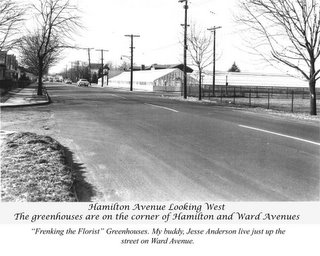 The photo indicates that the greenhouses were those of Frenking, the Florist. I have since found that this is not the case. The photo indicating it as the home of "Frenking the Florist" is in error.
